
Hyperspectral imaging, like other spectral imaging, collects and processes information from across the electromagnetic spectrum. The goal of hyperspectral imaging is to obtain the spectrum for each pixel in the image of a scene, with the purpose of finding objects, identifying materials, or detecting processes.
A Hyperspectral Imager is a type of remote sensing instrument that can accurately measure specific quantities for a number of disparate applications. Crop Health, Water Depth, Rock Type, Urban Landuse, and Fire Fuel Moisture are but a few. Satellite-based remote sensing is expensive due to many factors.
The human eye sees color of visible light in mostly three bands (red, green, and blue), spectral imaging divides the spectrum into many more bands. This technique of dividing images into bands can be extended beyond the visible. In hyperspectral imaging, the recorded spectra have fine wavelength resolution and cover a wide range of wavelengths.
Recent advances in remote sensing and geographic information has led the way for the development of hyperspectral sensors. Hyperspectral remote sensing, also known as imaging spectroscopy, is a relatively new technology that is currently being investigated by researchers and scientists with regard to the detection and identification of minerals, terrestial vegetation, and man-made materials and backgrounds.
Imaging spectroscopy has been used in the laboratory by physicists and chemists for over 100 years for identification of materials and their composition. Spectroscopy can be used to detect individual absorption features due to specific chemical bonds in a solid, liquid, or gas. Recently, with advancing technology, imaging spectroscopy has begun to focus on the Earth. The concept of hyperspectral remote sensing began in the mid-80’s and to this point has been used most widely by geologists for the mapping of minerals. Actual detection of materials is dependent on the spectral coverage, spectral resolution, and signal-to-noise of the spectrometer, the abundance of the material and the strength of absorption features for that material in the wavelength region measured.
Hyperspectral remote sensing combines imaging and spectroscopy in a single system which often includes large data sets and require new processing methods. Hyperspectral data sets are generally composed of about 100 to 200 spectral bands of relatively narrow bandwidths (5-10 nm), whereas, multispectral data sets are usually composed of about 5 to 10 bands of relatively large bandwidths (70-400 nm).
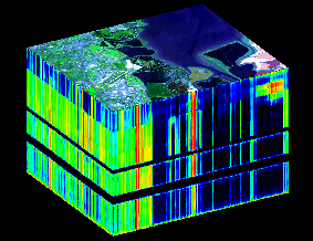
Hyperspectral imagery is typically collected (and represented) as a data cube with spatial information collected in the X-Y plane, and spectral information represented in the Z-direction.
Engineers build hyperspectral sensors and processing systems for applications in astronomy, agriculture, biomedical imaging, geosciences, physics, and surveillance. Hyperspectral sensors look at objects using a vast portion of the electromagnetic spectrum. Certain objects leave unique ‘fingerprints’ in the electromagnetic spectrum. Known as spectral signatures, these ‘fingerprints’ enable identification of the materials that make up a scanned object. For example, a spectral signature for oil helps geologists find new oil fields.
http://www.utexas.edu/
http://www.nasa.gov/