
Scarab: a wearable sensor platform that helps you stay safer and healthier. It is a mobile multi-sensor device that analyzes the world around you, allowing you to see the relevant data on your smartphone. The device features nitrogen dioxide, ambient light, temperature, UV index, 3-axis magnetic field, and many other sensors. In fact, it has 16 on-board sensors at this time.
The Scarab system has mobile apps, a web mapping service, and a community. The device gathers data from your surrounding environment and alerts you on your smartphone when you are in danger. Scarab will send its real time data to the cloud for further analysis and visualization.

Scarab: a wearable sensor platform
Scarab is part of a virtuous circle that includes mobile apps on your smartphone, a web mapping service, such as Google Maps, and a community of users. Scarab will be easy to set up and use. Just download the app, attach a Scarab to your bike, purse or backpack, and go!
Scarab’s Sensors See The World That You Can’t
![]() We are surrounded by an invisible topography of potentially dangerous gases, electromagnetic waves and radiation. Because we can’t see them, we don’t give them much thought. Now, with Scarab, you will be able to see, avoid and share information about dangerous areas with others in the Scarab community.
We are surrounded by an invisible topography of potentially dangerous gases, electromagnetic waves and radiation. Because we can’t see them, we don’t give them much thought. Now, with Scarab, you will be able to see, avoid and share information about dangerous areas with others in the Scarab community.
What onboard sensors does one Scarab have?
- Ambient Light sensor
- UV Index sensor
- Gamma detector
- Thermometer
- Relative Humidity sensor
- Noise Level detection circuit
- Digital Output Barometer
- Gyroscope
- 3D Magnetometer
- 3D Accelerometer
- GPS Module
- Three axis magnetic field sensor
- Liquid Petroleum Gas detector
- Carbon Monoxide detector
- Ozone detector
- Nitrogen Dioxide detector
robust processor in the device collates the sensors’ impressions and sends them to the Scarab mobile app on your smartphone via Bluetooth LE in order to be analyzed. If any of the sensors detects abnormal readings, the Scarab app will notify you immediately.
The Scarab app will collect your sensor data readings over time and will notify you of any dangers from long term buildup of exposure to dangers like UV.
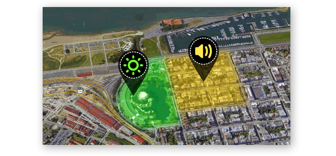
On the app, you’ll be able to see where you travelled on a map and the readings that Scarab recorded. Avoiding potential high danger areas is now super simple.
Via your smartphone, Scarab will send its real time data to the cloud for further analysis and visualization. Secure and anonymized, your data will mix with all other Scarab users to give the entire community a richer understanding of the invisible hazards on your street, in your city and around the world.
http://www.wearscarab.com/